ONLINE OIL SPILL ADVISORY SYSTEM
INTRODUCTION
India possessing sensitive ecosystems and aquatic organisms along its coastline of length 7517 km comprising estuaries, lagoons, mangroves, backwaters, salt marshes, mudflats, rocky shores and sandy structures. These marine habitats are being affected due to the oil spills caused due to vessel collisions and pipeline ruptures. Light fuels oils can cause mortality in 24-48 hours in red mangroves and black mangroves. Crude oils coat the prop roots and reduce the ability to exchange gases and Long term persistence cause leaf loss and lead to death. Coral reefs are the natural barriers that protect nearby shorelines from the eroding forces of the sea. They cover less than 1% of the Earth’s surface, they are home to 25% of all marine fish species. Oil spill will affect the health of the larger reef community. Some of the more territorial fish will even remain in the area until death. In order to prevent the impact of oil spills on the ecosystem and on the aquatic organisms an oil spill trajectory prediction system is required. In the event of oil spill, the direction and movement of the oil will be predicted in advance in this system and will be disseminated to the users. The clean up and control measures will be planned and carried out accordingly.
About OOSA
Online Oil spill Advisory System, a web portal, designed by INCOIS to issue online oil spill trajectory prediction during the event of oil spills was established during 2015. This system will eliminate the telephonic and fax traffic during the emergency situations in getting the advisory. INCOIS Online Oil Spill Advisory (OOSA) system is an integrated set up of oil spill trajectory model, General ocean circulation models, and atmospheric models and Geographical Information System (GIS).The oil spill trajectory model is customized and set for Indian Ocean domain. The ocean circulation patterns are obtained from INCOIS based high resolution Regional Ocean Modeling system, Hybrid co-ordinate ocean model and GODAS based Modular ocean models. The atmospheric fields are obtained from atmospheric models of ECMWF, NCMRWF and WRF. The resultant of the forcing on Euler's forward scheme yields the oil drift in spatio-temporal scale. The necessary details of the spill will be fed by the user to generate the predicted trajectory.
Oil Spill Trajectory Model In OOSA
GNOME (General National Oceanic and Atmospheric Administration (NOAA) Operational Modeling Environment), an oil spill trajectory model developed by NOAA is used for the simulation (Beegle Krause, 2001). GNOME was adopted and set in diagnostic mode for Indian Ocean. In diagnostic mode of operation, the user needs to feed wind, ocean currents and diffusion as per the prescribed format of GNOME. The trajectory model accepts the forcings from any hydrodynamic and ocean general circulation models of steady state, two and three dimensional time dependent type. The particles or splots of oil pollutant are considered as Lagrangian Elements (LE's). As the simulation progress, the LE's move away from each other due to the resultant of forcings. GNOME follows the forward Euler scheme, to get the displacement of an oil particle from the initial location over time (Beegle Krause et al. 2001).
GENARATING OIL DRIFT PATTERN- STANDARD OPERATING PROCEDURE (SOP)
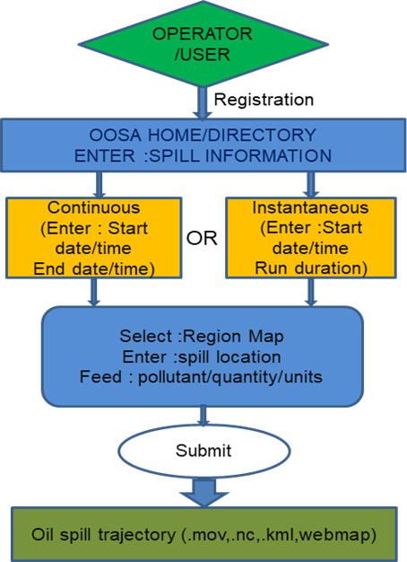
The operator/user can enter the home page after registration. The spill information can be given after selecting the type of spill. The map has to be selected and other details such as spill location, pollutant, quantity and the units have to be fed. Once after submission, the oil spill trajectory will be generated.